OUR OCEAN CONNECTOR
Traditional visual representations of our global ocean fail to accurately depict its true integrity. As our relationship with the ocean evolves, properly advocating for and protecting it demands a collective shift in how we imagine it.
Written by: Pascale Hunt

Image: USGS
Covering over two-thirds of our terraqueous Earth, the ocean is the planet’s largest ecosystem. This body of water provides us with the oxygen we breathe, regulates our climate, fuels the water cycle, and supplies nourishment and sustenance for billions of people. Home to an estimated 2 million species, we are yet to document 90% of them.
Not only does the global ocean play a vital role in our existence, it is increasingly the domain in which our existential struggles are being played out. While much of it remains undiscovered, the effects of human activities on the ocean and our planet as a whole have never been more clear. From ocean acidification, to sea level rise as a result of climate change, to the plastic crisis, overexploitation of fish stocks and destructive fishing practices, the ocean has a way of clarifying our confronting realities.
In our pursuit to address these multifaceted issues, we must question how we ended up in here. Perhaps the most logical starting point is to look at how dominant historical perceptions have viewed the ocean as a divider, rather than a uniter.

“With every drop of water you drink, every breath you take, you’re connected to the sea.”
The ocean as ‘other’
Early European voyagers, academics, and cartographers conceptualised the ocean as ‘blank space’ between nation states, maintaining an imposed aura of ‘otherness’ - mysterious, and without agency.
Franz Boas, one of the most prominent figures in the academic discipline of anthropology - the study of human culture - saw the transient, malleable and mutable nature of water in the form of rivers, rain, snow and seas as useful metaphors in the communication of his well-known cultural relativist theory. Another prominent anthropologist Claude Levi-Strauss’s structuralist theory of ‘binary opposites’ was built on his feeling that the practice of anthropology involved “hold[ing] theory in abeyance while at sea, only to set it in motion once the ethnographer hits land”, implying the ocean was culturally neutral. The distinct discipline of maritime anthropology was eventually established, but even in this field, early publications described how “peasant fishermen were seen as hybrids - only with one foot planted [on the land] could these fishermen appear as legitimate subjects of study”.
This indifference towards the ocean as an area of anthropological study makes more sense when viewing the discipline through the lens of colonialism, a practice wholly related to the conquest of land. Anthropology was, as Icelandic anthropologist Palsson points out,
“borne, as was colonialism, as a result of voyages by sea… different and isolated worlds were connected into a global but polarized network of power relations”.
Elizabeth DeLoughrey echoed this sentiment in her essay ‘The sea is rising: Visualising climate change in the Pacific Islands’, noting that the Pacific Basin has been traditionally characterised as “a vast, empty, feminized ocean, to be filled by masculine European voyagers”.
Prominent Pacific scholar Epeli Hau’ofa has similarly argued that Europeans have historically belittled Oceania and the Pacific through their construction of the region as a ‘scattering of islands’ rather than as a ‘sea of islands’, emphasising:
“this ‘sea of islands’ is actually connected, not divided, by water.”

Image: Julie Froelich
The ocean mapped
Since we’re not in a position in space to view the Earth as a whole directly, the images of the Earth that we encounter and produce are in the form of indexes, icons, and symbols, which have been influenced by particularities in political, philosophical, and cultural perspectives held by the producers of such representations. In the most widely circulated maps of the world, the prominence of certain continents over others is a product of these biases.
The map below known as the Mercator Projection is arguably the most recognizable and widely used map projection of the Earth.
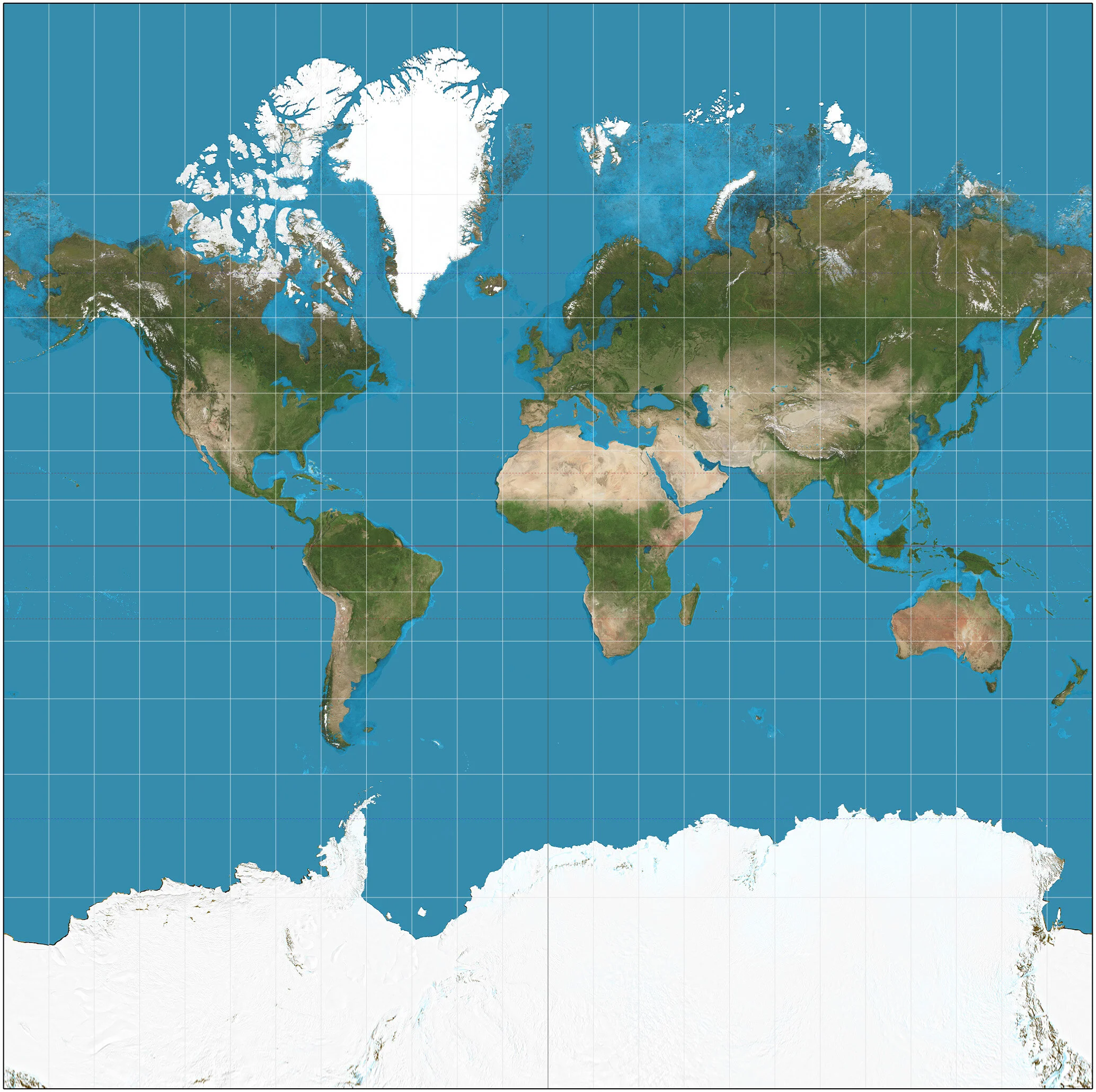
Image: Strebe
The Mercator Projection sees the ‘cut’ in the Earth’s ‘skin’ occurring from the North Geographic Pole to the South Geographic Pole, which effectively cuts along and separates the ocean. It’s known for maintaining the accurate shapes of the land masses while distorting their sizes, with countries in Asia and the African continent appearing notably smaller than they truly are.
The Spilhaus Projection
The map below takes an alternative approach to representing the Earth’s surface. Known as the Spilhaus Projection, it is accredited to South African-American geophysicist and oceanographer Athelstan F. Spilhaus, whose pursuit to create a ‘world ocean map’ led him to find ocean surfaces could be stretched out in all directions without distortion, by using Antarctica at the centre.

Image: Spilhaus, "To see the oceans, slice up the land". Smithsonian, November, 1979
Spilhaus mapped what he called “a water planet” - arguing “if the map is to be of the whole ocean, the singular point must be chosen in the land and, to get minimum distortion in the oceans, it should be chosen at a point within the land furthest distance in any direction from the sea”.
The map was created in collaboration with geodesists Robert Hanson and Erwin Schmid initially in 1942, who devised the equations and programmed the computers to make the map while Spilhaus was concurrently inventing the bathythermograph, a device for measuring ocean depths and temperatures.
In contrast to the type of maps we are used to, in the Spilhaus Projection land masses aside from Antarctica and Australia are represented as ‘ocean borders’. Conversely, the ocean is transformed from negative into positive space - occupying the foreground as one uninterrupted body of water.
Spilhaus wrote in his 1983 essay ‘World Ocean Maps: The Proper Places to Interrupt’:
“the objective was to devise maps which showed the whole world ocean as a connected, single body of water uninterrupted by the edge of the map. To make such maps for the semi-connected continents forming the land island is comparatively trivial, because land covers only 29 percent of the globe”.
The Antarctic basin which is featured centrally in the Spilhaus map completely encircles Antarctica and extends north to 60 degrees latitude, the boundaries of which were first proposed by the International Hydrographic Organization (IHO) in 2000 in their publication ‘The Limits of Oceans and Seas’. Storing approximately 75% of the heat absorbed by the entire ocean (which absorbs more than 90% of excess heat produced by burning fossil fuels) and approximately 35% of excess carbon absorbed globally, this relatively new basin is quite literally the planetary centre for heat and carbon storage. It also acts as a connector of all the major oceans with the exception of the Arctic ocean.
The Spilhaus projection went viral on social media in 2018, shared by ocean lovers and environmentalists as a call to action for protecting the world’s ocean. Marine geoscientist Russell Wynn said of the Spilhaus Projection:
“It truly illuminates why we live on planet Ocean rather than planet Earth…it demonstrates the interconnectedness of our oceans and the need for coordinated international action if we are to tackle growing issues such as acidification, deoxygenation, overfishing and pollution”.

Image: Tina Rolf
The potency of visual canon
The way we think and act upon our environment is deeply influenced by the way in which we visualize it. The famous ‘Earthrise’ photograph taken from the Apollo 8 spacecraft in 1968 depicted the Earth ‘rising’ from behind the Moon and was widely circulated as the cover of the Whole Earth Catalog in 1969. At the time, the publication was seen as supporting a ‘back to the Earth’ counterculture and played an important role in the globalization and environmentalization of the Earthrise image.

Image: Earthrise, NASA
This attribution of meaning to the image of the Earth bestowed it with iconic properties, which implied a “a quality of Earth - it’s wholeness”. In 1972, another photograph taken from Apollo 17 known as ‘Blue Marble’ became more iconic still, a moment that some described as when the globe became an ‘eco-object’:
“a revelatory image, pregnant with power in and of itself”.

Image: Blue Marble, NASA’s Marshall Space Flight Center
These unprecedented photographs of the Earth from space became powerful visual canon for environmentalists following the first Earth Day in 1970, when scientific and activist communities began increasingly speaking of the Earth as a blue planet. Feminist theorist and author Donna Haraway wrote in 1995:
“These images could be seen as a call to intimacy with the planet, a yearning for the physical sensuousness of a wet and blue-green Earth.”
In 2010, American author, environmentalist, and co-founder of 350.org Bill McKibben argued ‘we no longer live’ on the planet represented in the Earthrise photo. His book Eaarth points to melting ice caps and acidic oceans, with an added silent ‘a’ in ‘Eaarth’ to highlight the “silent but significant change” humanity has wrought on our planet.
Spheres of importance: an oceanic shift
Climate change is already having a dramatic impact on the ocean. Sea levels are rising at a rate of 0.13 inches per year, the Greenland ice sheet is melting at a rate of 287 billion tons a year, and the Antarctic ice sheet is losing 134 billion tons per year according to NASA.

Image: Sergey Kuznetsov
Despite the Antarctic being considered the most remote and wild location on the planet, scientists recently discovered penguin populations in this area have declined by 50%, with some having declined by as much as 77%, likely as a result of climate change. This icy wet landscape is also home to a myriad of rare marine species, including Humpback whales, orcas and seals. The harsh conditions here make explorations difficult, but more information is being obtained at an exponential rate with the help of robotics and satellite technology. Recent expeditions using robotics have discovered thriving communities of giant invertebrates living around hydrothermal vent systems that expel energy from the Earth’s crust.
Where the ocean has traditionally been viewed as a passive bystander, it is now increasingly intertwined with both our understanding of the origins of life on Earth and, critically, the future of it. In the last decade, much of the global population has been inundated with heartbreaking images of our ocean plastic crisis with the help of social media. From animals entangled in consumer waste products to the Great Pacific Garbage Patch, these issues have become the subject of countless headlines and viral posts with innumerable organisations devoted to addressing specific ocean issues. It’s undeniable that the depiction of these realities through visual media has played an immeasurable role in rallying activism and facilitating a cultural attitude shift towards the state of the ocean.
A profound media moment was created in the Maldives in 2009 when at a meeting staged 20 feet below sea level, Maldivian officials calling for environmental justice signed a document imploring the international community to urgently cut carbon emissions. As climate change induced sea level rise threatens to envelop as much as 77% of the many of the 1,192 islands in the archipelago by the end of the century, the Maldives as well as many other Pacific island nations will disproportionately experience the impacts of the climate crisis.

Image: Hoodh Ahmed
While our climate futures will play out in and around the ocean, there is a simultaneous oceanization of the geopolitical sphere at play. The pursuit of increasingly scarce marine resources like fish, oil and minerals will exacerbate resource inequality between the global South and the more industrialised North, while territorial disputes in the ocean such as those developing in the South China Sea have the potential to escalate into serious security issues over the coming decades. Correspondingly, the development of economic activities in the ocean is increasing rapidly as interest, investment, and innovation expands each year.
In her Keynote Speech at the 2020 World Conference on Marine Biodiversity in New Zealand, Aulani Wilhelm, Senior Vice President of Oceans at Conservation International, referred to the disparity between how island nations view the ocean as a connector, versus how the ocean has been treated in general as a bottomless resource for extraction. She had previously told Global Citizen how in her homeland of Hawaii,
“there’s this sense that the ocean isn’t a barrier, but that it’s what connects us.”
Globalization and today’s advanced technologies have somewhat blurred distinctions between places on Earth - we have the ability to come into contact with other locations and their virtual representations with great ease. But while the process of globalization itself is often discussed in watery terms: flows, fluidity, circulations and ripples - in our dominant visual representations of the planet, the ocean is still portrayed as a docile, passive, negative space - lapping up against the coastlines of highly detailed, high-visibility continents.
These representations fail to capture the size, true connective integrity, and fundamental role the ocean plays in our existence, and may hinder our ability to properly advocate for it. As environmental justice issues, conflicts in the geopolitical sphere, and economic development become increasingly intertwined with the ocean, it’s vital place and shape in our reality must be accompanied by an oceanization of our collective imaginations.

Image: Magda Ehlers
Author: Pascale Hunt
Pascale is a journalist and communications professional focusing on environmental and human rights issues impacting the Asia-Pacific region.